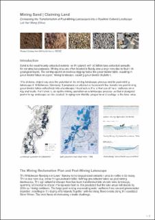
| dc.description | Sand is the most heavily extracted material on the planet, with 50 billion tons extracted annually for construction purposes. Mining sites are often located in floodplains along rivers due to their rich geological layers. The mining operation involves digging below the groundwater table, resulting in groundwater lakes as a post-mining landscape, causing groundwater depletion.
This diploma project explores the potential of the mining landscape process and its post-mining lakescape in Mittelweser, Germany. It proposes an alternative framework that transforms post-mining groundwater lakes collectively into a landscape infrastructure that enhances climate resilience on a regional scale. Furthermore, using the mining operation as a landscape process, so that a designed post-mining landscape can be created, bringing new identity, programs and ecology to the local area.
image1_1.jpg
The Mining Reclamation Plan and Post-Mining Lakescape
The Mittelweser floodplain is the largest sand extraction area in northern Germany. The mines have dug below the groundwater table, forming groundwater lakes as post-mining landscapes. The agricultural landscape thus has been transformed into an extensive lakescape, spanning 500 hectares of post-mining water bodies. It is predicted that the lake areas will double by 2035 as mining continues. The large post-mining evaporating water surfaces have caused groundwater depletion, resulting in the drying of farmlands.Together with the rising flood events along the canalized River Weser. The area faces an increasing climate challenge.
image2_0.jpg
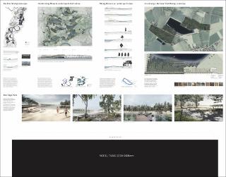
Transforming Mines to Landscape Infrastructures
Given these challenges, the project proposes an alternative landscape framework that enhances climate resilience while utilizing only 50% of the current mining plan to address concerns regarding arable land loss. The new landscape structure scatters and connects the groundwater lakes with existing ditches to collect rainwater, expands forest patches along the lakes to form riparian detention areas, and introduces small sealed irrigation ponds for the dry season. The composition of the landscape is aesthetically guided by farming plots, creating a multifunctional cultural landscape that showcases the enhanced geological dynamics of the river meander.
image3_0.jpg
Using the Mining Process as a Landscape Process
The project leverages the mining process as a methodology to shape the landscape, developing the “Cut-Fill-Cultivation” model that evolves the mining operation, closure and rehabilitation procedures. This design and construction methodology is tailored to the unique characteristics of the mining landscape and effectively integrates the mining process into designing and constructing the post-mining landscape. However, current practice focuses on stabilizing mine edges using limited slope ratios of 1:2 to 1:5. By incorporating a greater variety of water edges and slope ratios, the project creates riparian zones that respond to groundwater level fluctuations, providing diverse habitats, recreational opportunities for both humans and wildlife.
Envisioning a Nurtured Post-Mining Landscape
The project envisions a new blue-green post mining landscape by cutting, filling and cultivating the mining landscape. The created water edges of diverse terrain profile, are filled with materials sourced and recycled from mining and local farms. It creates the sandy beach, brick seatsteps, rocky shore, wetland boardwalk and riparian woodland, bringing various water experiences and a performative resilient ecosystem.
Conclusion
The mining of sand, a heavily extracted material, has resulted in the creation of large water bodies that are typically left to nature’s reclamation. However, through creative landscape design, these post-mining landscapes can be transformed into multi-functional landscape infrastructures that enhance climate resilience and provide new identity, programmes and ecology to the local area. By utilizing the mining process to develop a “ cut- fill- cultivation ” design and construction model, a more diverse edge environment of the post-mining landscape can be created, benefiting both people and wildlife.
The proposed project in Mittelweser, Germany serves as a model for other regions grappling with the impact of mining activities on their landscape. It is a call for a new perspective on post-industrial landscapes and an opportunity to reimagine them as assets rather than liabilities. | en_US |